Batu Pahat District
The Batu Pahat District is a district in the state of Johor, Malaysia. It lies southeast of Muar, southwest of Kluang, northwest of Pontian, south of Segamat and Tangkak District. The capital of the district is Bandar Penggaram.
The capital of the district Bandar Penggaram, Batu Pahat is located at 1°51′N 102°56′E. It is 239 km (150 miles) from Kuala Lumpur. The next nearest town is Muar which is 50 km (30 miles) northwest of Batu Pahat. The town of Kluang is located about 52 km (32 miles) to the northeast. Johor Bahru is located about 70 km to 100 km (43 miles to 62 miles) to the southeast of the town.
The district itself borders the districts of Segamat to the north, Kluang to the east, Muar to the west and shares a border in the southeast with the district of Pontian. The coast of the Straits of Melaka lies to the south.
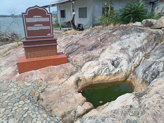
The town acquired the name Batu Pahat, which means “chiselled stone”, from the quarries near the estuary.[3] There are multiple theories as to the origin of this name. In around 1456, the Siamese army, led by Admiral Awi Di Chu, camped in Batu Pahat before attacking Malacca.[4] Legend has it that the invading Siamese troops were chiselling rocks at a rocky spot in the coastal village of Kampung Minyak Beku, in hope to get fresh water during their retreat from the Melaka troops, led by Tun Perak, the famous Bendahara (Prime Minister) of the Malacca Empire. Another possible explanation for the origin of the name is the fortress (“a famosa”) built by the Portuguese after capturing Melaka, which was made from granite rocks taken from the mouth of Sungai Batu Pahat.
Renowned for its salted fish in the past, Batu Pahat was formerly known as Bandar Penggaram, which means “town of salt-makers”. In 1893/1894, the present township was founded by Dato’ Bentara Luar, Mohamed Salleh bin Perang, acting on the orders of the Sultan of Johor, Sultan Abu Bakar.[5]
Batu Pahat was the location of the headquarters for the 1Bn Fiji Infantry Regiment, serving as part of the Commonwealth forces during the Malayan Emergency, from 1952 to 1956. The 1,600 strong force saw considerable action during the campaign and contributed to the securing of the area during that period.[6]
16 October 1980 was marked as one of Batu Pahat’s bloodiest day in recent history. At approximately 9:30 AM, 20 Muslim extremists led by Mohd. Nasir Ismail, stormed into the Batu Pahat Police station with machetes, slashing and injuring 23 police staff and civilians. 8 of the extremists were shot dead by the police. The motive of the attack was never fully determined.[7]
Today, the ancient well can still be found in Minyak Beku, though little was done to maintain this ancient landmark which gives name to the town. For the town’s centennial celebration in the early ’90s, a quaint monument depicting a floating hand chiselling a rock was set up in the town square. It became the landmark of the town instantaneously. Currently, the newly refurbished town square is popular with locals on weekend nights and also provides as a venue for many public festive celebrations.