Lake Atitlán
Lake Atitlán (Spanish: Lago de Atitlán, [atiˈtlan]) is a lake in the Guatemalan Highlands of the Sierra Madre mountain range. It is in the Sololá Department of southwestern Guatemala. It is the deepest lake in Central America.
Atitlán means “between the waters”. In the Nahuatl language, “atl” is the word for water,[2] and “titlan” means between.[3] The “tl” at the end of the word “atl” is dropped and the words are combined to form “Atitlán”.
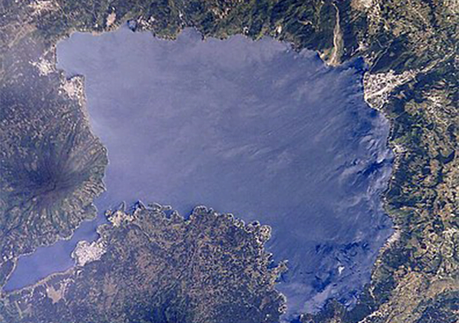
Lake Atitlán is a lake in Guatemala with a maximum depth of about 340 metres (1,120 ft)[1] with an average depth of 220 metres (720 ft).[4] Its surface area is 130.1 km2 (50.2 sq mi).[1] It is approximately 18 km × 8 km (11.2 mi × 5.0 mi) with around 20 km3 (4.8 cu mi) of water. Atitlán is technically an endorheic lake, feeding into two nearby rivers rather than draining into the ocean. It is shaped by deep surrounding escarpments and three volcanoes on its southern flank. The lake basin is volcanic in origin, filling an enormous caldera formed by an eruption 84,000 years ago.
The culture of the towns and villages surrounding Lake Atitlán is influenced by the Maya people. The lake is about 50 kilometres (31 mi) west-northwest of Antigua. It should not be confused with the smaller Lake Amatitlán.
Lake Atitlán is renowned as one of the most beautiful lakes in the world, and is one of Guatemala’s most important national and international tourist attraction.[4] German explorer and naturalist Alexander von Humboldt called it “the most beautiful lake in the world,” and Aldous Huxley famously wrote of it in his 1934 travel book Beyond the Mexique Bay: “Lake Como, it seems to me, touches on the limit of permissibly picturesque, but Atitlán is Como with additional embellishments of several immense volcanoes. It really is too much of a good thing.”
The area around San Marcos has particularly tall cliffs abutting the lake and in recent years has become renowned for cliff diving.
The first volcanic activity in the region occurred about 11 million years ago, and since then the region has seen four separate episodes of volcanic growth and caldera collapse, the most recent of which began about 1.8 million years ago and culminated in the formation of the present caldera. The lake now fills a large part of the caldera, reaching depths of up to 340 m (1,120 ft).
The caldera-forming eruption is known as Los Chocoyos eruption and ejected up to 300 km3 (72 cu mi) of tephra. The enormous eruption dispersed ash over an area of some 6,000,000 square kilometres (2,300,000 sq mi): it has been detected from Florida to Ecuador, and can be used as a stratigraphic marker in both the Pacific and Atlantic oceans (known as Y-8 ash in marine deposits).[8] A chocoyo is a type of bird which is often found nesting in the relatively soft ash layer.
Since the end of Los Chocoyos, continuing volcanic activity has built three volcanoes in the caldera. Volcán Atitlán lies on the southern rim of the caldera, while Volcán San Pedro and Volcán Tolimán lie within the caldera. San Pedro is the oldest of the three and seems to have stopped erupting about 40,000 years ago. Tolimán began growing after San Pedro stopped erupting and probably remains active, although it has not erupted in historic times. Atitlán has developed almost entirely in the last 10,000 years and remains active, its most recent eruption having occurred in 1853.