North American Plate
The North American Plate is a tectonic plate covering most of North America, Cuba, the Bahamas, extreme northeastern Asia, and parts of Iceland and the Azores. With an area of 76 million km2 (29 million sq mi), it is the Earth’s second largest tectonic plate, behind the Pacific Plate (which borders the plate to the west).
It extends eastward to the Mid-Atlantic Ridge and westward to the Chersky Range in eastern Siberia. The plate includes both continental and oceanic crust. The interior of the main continental landmass includes an extensive granitic core called a craton. Along most of the edges of this craton are fragments of crustal material called terranes, which are accreted to the craton by tectonic actions over a long span of time. It is thought that much of North America west of the Rocky Mountains is composed of such terranes.
The southern boundary with the Cocos Plate to the west and the Caribbean Plate to the east is a transform fault, represented by the Swan Islands Transform Fault under the Caribbean Sea and the Motagua Fault through Guatemala. The parallel Septentrional and Enriquillo–Plantain Garden faults, which run through the island of Hispaniola and bound the Gonâve Microplate, are also a part of the boundary. The rest of the southerly margin which extends east to the Mid Atlantic Ridge and marks the boundary between the North American Plate and the South American Plate is vague but located near the Fifteen-Twenty Fracture Zone around 16°N.
On the northerly boundary is a continuation of the Mid-Atlantic ridge called the Gakkel Ridge. The rest of the boundary in the far northwestern part of the plate extends into Siberia. This boundary continues from the end of the Gakkel Ridge as the Laptev Sea Rift, on to a transitional deformation zone in the Chersky Range, then the Ulakhan Fault between it and the Okhotsk Plate, and finally the Aleutian Trench to the end of the Queen Charlotte Fault system.
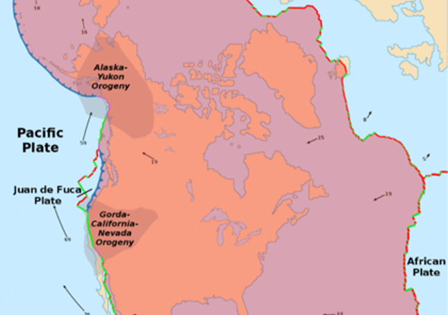
The westerly boundary is the Queen Charlotte Fault running offshore along the coast of Alaska and the Cascadia subduction zone to the north, the San Andreas Fault through California, the East Pacific Rise in the Gulf of California, and the Middle America Trench to the south.
On its western edge, the Farallon Plate has been subducting under the North American Plate since the Jurassic Period. The Farallon Plate has almost completely subducted beneath the western portion of the North American Plate leaving that part of the North American Plate in contact with the Pacific Plate as the San Andreas Fault. The Juan de Fuca, Explorer, Gorda, Rivera, Cocos and Nazca plates are remnants of the Farallon Plate.
The boundary along the Gulf of California is complex. The Gulf is underlain by the Gulf of California Rift Zone, a series of rift basins and transform fault segments between the northern end of the East Pacific Rise in the mouth of the gulf to the San Andreas Fault system in the vicinity of the Salton Trough rift/Brawley seismic zone.
It is generally accepted that a piece of the North American Plate was broken off and transported north as the East Pacific Rise propagated northward, creating the Gulf of California. However, it is as yet unclear whether the oceanic crust east of the Rise and west of the mainland coast of Mexico is actually a new plate beginning to converge with the North American Plate, consistent with the standard model of rift zone spreading centers generally.