Ramganga
Ramganga is a tributary of the river Ganga, originating in Uttarakhand state, India.
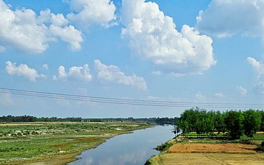
The Ramganga River originates in the southern slopes of Dudhatoli Hill in chamoli district of the Indian state of Uttarakhand. The source of the river, known as “Diwali Khal”, is located in Gairsain tehsil at 30°05′00″N 79°18′00″E. The river flows by the town of Gairsain, however the town is located at a much higher altitude than the river. The river then enters the Almora district of Kumaon through a deep and narrow valley in Chaukhutia tehsil. Emerging from there, it turns southwest and receives the Tadagatal River, wandering widely around the southeastern boundary of Lohabagarhi. It then proceeds further in the same direction and reaches Ganai, where it receives the Kharogad coming from Dunagiri from the left and Khetasargad coming from Pandnakhal from the right.
Coming out of the Ganai, it flows towards the Talla Giwar region, where there is an open valley with alluvial land along and around the river, which is extensively cultivated and irrigated by the waters of the river. After Masi, the valley shrinks to some extent, but some fertile plains are still found up to the Briddhakedar temple. Here it receives the Vinod river, which originates from Chaukot, and from this point onwards the flow of the river turns southwards, and mountains filled with fertile soil and rocks can be seen on either sides of the river. Eleven miles further from Masi, it reaches Bhikiyasain, where it receives the Gagas from the east and Naurargad from the south. Here the valley widens once again, but irrigation still depends mainly on minor streams. From Bhikiyasain the river takes a sharp turn towards the west and receives Nail river from Salt and Devgad from Garhwal. It forms the boundary of Almora and Pauri Garhwal districts to some extent after the Marchula Bridge. The river then enters Bhabar and flows westward from Patli Dun into the Jim Corbett National Park.