Kameng River
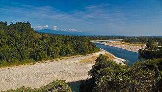
The Kameng River (previously named Bharali River, now called Kameng in Arunachal Pradesh and Jiabharali (Jia Bharali) in Assam) in the eastern Himalayan mountains, originates in Tawang district from the glacial lake below snow-capped Gori Chen mountain WikiMiniAtlas27°48′36″N 92°26′38″E,[1] elevation 6,300 metres (20,669 ft),[2][3] on the India-Tibet border in South Tibet and flows through Bhalukpong circle of West Kameng District, Arunachal Pradesh and Sonitpur District of Assam, India. It becomes a braided river in its lower reaches[4] and is one of the major tributaries of the Brahmaputra River, joining it at Tezpur, just east of the Kolia Bhomora Setu bridge.[5]
The Kameng River is about 264 kilometres (164 mi) long. Its drainage basin is about 11,843 square kilometres (4,573 sq mi) large.[6]
The Kameng forms the boundary between East Kamemg District and West Kameng Districts and is also the boundary between the Sessa and Eaglenest sanctuaries to its west and the Pakke tiger reserve to the east.[7] The Dafla Hills are east and the Aka Hills (home of Aka tribe) are west of the Kameng River. The entire stretch of forest along the Bhalukpong–Bomdila highway on the west bank of the river in West Kameng has vanished in the last few years though the forest across the river continues to be in a healthy state.[8]