Great Kei River

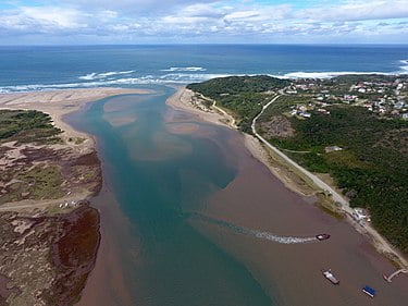
The Great Kei River is a river in the Eastern Cape province of South Africa. It is formed by the confluence of the Black Kei River and White Kei River, northeast of Cathcart. It flows for 320 km (199 mi)[1] and ends in the Great Kei Estuary at the Indian Ocean with the small town Kei Mouth on the west bank. Historically the Great Kei River formed the southwestern border of the Transkei region as was formerly known as the Nciba River.
The Great Kei River is a meandering river course and is formed by the convergence of the Black Kei River and the White Kei River in Enoch Mgijima Local Municipality, north-east of Cathcart and southeast of Queenstown. The Great Kei river flows from the junction of the Black and White Kei rivers for approximately 225 kilometers (140 miles) southeastwards along winding courses to the Indian Ocean. It terminates at the Great Kei estuary by Kei Mouth, a coastal resort town. Its longest tributary is the Tsomo in the north. The name has it origins as far back as 1752 and is based on a Khoisan word for the river meaning ‘sand’.
The Great Kei previously formed the southwestern border of the Transkei region which can be accessed via the ‘Pont’, one of only two car-transporting river ferries in South Africa.[2] The pont is currently operational and motorists are frequently ferried from the southwestern bank to the northeastern bank into the Wild Coast.
