Ili (river)
The Ili (Uighur: ئىلى دەرياسى, romanized: Ili deryasi, lit. ’Ili dəryasi’; Kazakh: Ile, ئله; Russian: Или; Chinese: 伊犁河; pinyin: Yīlí Hé, Dungan: Йили хә, Xiao’erjing: اِلِ حْ; Mongolian: Ил, literally “Bareness”) is a river situated in Northwest China and Southeastern Kazakhstan. It flows from the Ili Kazakh Autonomous Prefecture of the Xinjiang Uighur Autonomous Region to the Almaty Region in Kazakhstan.
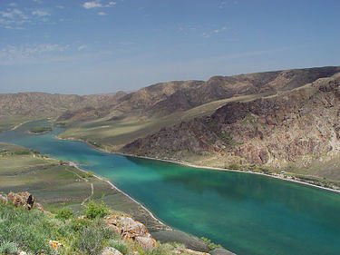
It is 1,439 kilometres (894 mi) long (including its source river Tekes),[2] 815 kilometres (506 mi) of which is in Kazakhstan. The river originates from the Tekes and Künes rivers in Eastern Tian Shan. The Ili drains the basin between the Tian Shan and the Borohoro Mountains. Flowing into Lake Balkhash, the Ili forms a large delta with vast wetland regions of lakes, marshes and vegetation.[3][4]
Earlier mentions of Ili river can be traced back to the Mahmud al-Kashgari’s dictionary of Turkic languages, the Dīwānu l-Luġat al-Turk (written in 1072–74). In the book, the author defines it in the following way: “Ili, the name of a river. Turkic tribes of Yaghma, Tokhsi and Chiglig live on its banks. Turkish countries regard the river as their Jayhoun (Amu Darya).”[5] The name possibly originated from Uyghur word Il, meaning hook, resembling the river’s geographical shape.[6]
The upper Ili Valley is separated from the Dzungarian Basin in the north (by the Borohoro Mountains), and from the Tarim Basin in the south (by the Tian Shan). This region was the stronghold of the Qing administration in Xinjiang in the late 18th and 19th centuries. It was occupied by Russia from 1871 to 1881 (from the Yaqub Beg rebellion until the Treaty of Saint Petersburg (1881)).